Global Epidemic and Mobility Model.
"As the growing worldwide population becomes more mobile and urbanized, the risks that infectious diseases epidemic and their associated threats may reach global proportions are constantly increasing.
To effectively limit the social and economic damage caused by infectious diseases, the public health communities need to be in the position to anticipate the spatial and temporal evolution of epidemics and evaluate the potential impact of available containment and prevention strategies.
The global epidemic and mobility model, GLEAM, combines real-world data on populations and human mobility with elaborate stochastic models of disease transmission to deliver analytic and forecasting power to address the challenges faced in developing intervention strategies that minimize the impact of potentially devastating epidemics."
www.gleamviz..org
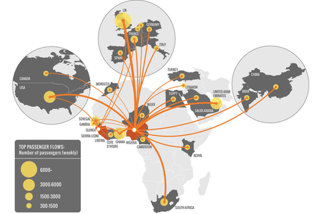
Assessing the international spreading risk associated with the 2014 West African Ebola outbreak.
|
In September 2014 the rapid evolving situation of the Ebola Outbreak in West Africa raised the need of continuous updates of the models as more and more data became available from the affected region.The access to this data allowed us to recalibrate our model, improving the projections and analysis. After we published the first article, we created a website (http://www.mobs-lab.org/ebola.html) where we have been continuously updating our initial results.
|
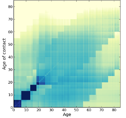
Synthetic Populations
|
The accurate characterization of the structure of social contacts in mathematical and computational models of infectious disease transmission is a key element in the assessment of the impact of epidemic outbreaks and in the evaluation of effective control measures. For instance, the transmissibility potential of a disease and the final epidemic size strongly depend on mixing patterns between individuals of the population, which in turn depend on socio-demographic parameters (e.g. household size, fraction of workers and students in the population). Empirical data collection on a large scale is however extremely difficult and although several models tackling both new emerging epidemics and endemic diseases have introduced a significant amount of information on contact patterns, it is clear that the increasing use of data-driven models in the support of public health decisions is calling for novel approaches to the estimation of mixing patterns in human populations.
|
|
Epidemic Rapid Transit Map: Epi-Rail
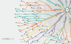
The Epidemic Rapid Transit Map shows a hypothetical pandemic scenario starting in Hanoi, Vietnam. The epidemic simulations are performed with GLEAM and the disease dynamic has the same transmission parameters of the H1N1 2009 pandemic. In the map the different stops represent the cities reached by the disease. Some of them work as final destinations, while the major cities work as transfer stations, where the people traveling could follow different paths according to their final destinations. This network representation of the spreading of the disease puts in evidence the fact that even very remote regions can be reached by a disease, as long as a connection to the rest of the world exists. It also highlights the relevant role played by some cities with a large number of connections (hubs), such as New York, London and Paris among others. In the background, we show the complete tree of the epidemic invasion network made of 3,362 census areas in the world.